Nature Hates Meadows!
Before you all think I'm getting a little extreme even for me, let me lay out my case:
Winter 05/06: Tree falls and takes out Shooting Star
Before you all think I'm getting a little extreme even for me, let me lay out my case:
Winter 05/06: Tree falls and takes out Shooting Star
Summer ’06: A near miss lightning strike starts the Bluegrass Ridge Fire complex, just north of meadows (I guess lightning is hard to aim, God may want to look into electronic guiding systems)
Fall ’06: Simultaneous attack by White River and Clark Creek to cut-off meadows from the rest of the world.
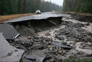
I want to know what the government is going to do about it? Where is Homeland Security now? We need to be opening a new front on the war on terror, and start to fight nature where nature is, or we will be fighting nature where it isn’t….huh?....Anyway, there is a new Axis of Evil: Trees, Lighning and Rain. They are working together to strike fear into heart of all Freedom loving glissaders.
Thanks to Nature, meadows remains closed. And not likely to open until sometime in December. In the meantime, staff at meadows are grooming the ski area to “compact the snow and prevent loss from wind transport”. My ass they are, those bastards are up there grooming a few runouts and skiing the hell out of the place, all to themselves….Now I wish I was a Groomer more than ever….

And now, thanks to the closure, all the Timberline pass holders almost look smart, except that Meadows being closed doesn’t make the terrain there any less flat, so while they may be skiing, they’re still skiing crappy terrain. Come January they’ll be suckers again…..
OK the forecast: Since we don’t need to be too concerned with the specifics I’ll just go with a general short-to-medium range forecast:
The Westerly flow seems to be poised and ready to pump more moderate to heavy rainfall into the region. As such, we could see some very interesting weather in November and December, and even into January. I will stay the course and keep us wet, Blustery and rather mild. However, heavy Mtn snows likely under this regime as well!
I can see some very interesting weather issues during this period but it will depend on the offshore ridge and the deep low over the Gulf and North Pac. It still appears to me that the ridge will flatten and allow some active weather to move over the top of the ridge, then drop down along the coast, then inland over the West and PacNW. If this holds true, then we could see some very interesting weather ahead. The longer term means show a much flatter weather mode as well as a flatter offshore ridge. If this is the case, then we would be in position to see some very active weather due to the Active Jet over the West. I will play the forecasts in that direction. Of note, the pattern is very flat but does support some surges of colder air dropping SE from the Gulf next week and beyond. This seems to be a variable mode right now which means that we will see colder air next week, then moderating the following week, but then returning to a colder mode as we enter into December. Heights aloft seem to hold between 534 to 558 over the PacNW, which is a very wet mode for us, and can be cool too. The above heights correspond to snow levels ranging from around 1,500 to 5,500 ft., but this is certainly low enough to build a decent snowpack for so early in the season. Of course, this can be variable but I think we will see ample snow into December, and beyond!
I really look at how amplified or how flat the global pattern is in the Fall season. That tells me a lot about the coming season. Right now, the overall global pattern is rather flat, and the means maintain this flatness as well. This indicates that we are likely to see some active frontal passages and heavy rainfall over the orographically enhanced mtn ranges. This certainly favors some heavy Mtn rains and snows over the Cascades, and Bull run. If all goes well, this will once again be a great water year! Obviously, we are off to a great start already!!
In years of El Nino, the pattern has been fragmented and broken offshore. I am not seeing this now, nor do I expect this to happen later in the season. This is all tied to the global weather pattern which is influenced more by activity to the North than to the South, as such, I will look mostly at the North Pac weather pattern, than the tropical Pac mode.
All in all, I think November and December will be very wet for us, and will stay the course with those feelings. Also, I like the overall weather pattern ahead with respects to snowfall. The pattern does favor a heavy snowfall mode as snow levels lower and moisture taps keep coming. As such, we will stay very wet indeed and snowy
All in all, I think November and December will be very wet for us, and will stay the course with those feelings. Also, I like the overall weather pattern ahead with respects to snowfall. The pattern does favor a heavy snowfall mode as snow levels lower and moisture taps keep coming. As such, we will stay very wet indeed and snowy
(by Phil Volker, posted without permission)
